Most railways relay today on the standard weather information which is available from the national weather services. Despite the fact the coverage of weather stations in Europe is rather good, the standard service has some disadvantages:
Information about weather conditions and developments have to be actively searched for by the people who work with them within the railways
Weather information is rather general and not related to the line section topology of railway infrastructure
Weather warnings are very general. Often the spatial and temporal resolution and/ or the reliability are rather low
Pre-warning times are rather short leaving little time to act
There is no priorisation of those data which are especially relevant for the railways
To overcome these limitations, some railways have introduced dedicated weather information and weather warning systems. A very important feature of the good practice examples in the field is the filtering and focus of those weather information relevant for the operation of railway infrastructure and rolling stock such as expected gales and storms, events with heavy or prolonged precipitation, sudden temperature changes or leave fall. Another feature of those systems is the automatic transmission of important weather information to the relevant people within the railway company either by e-mail, GSM(-R) mobile communication network or both. Thus, the number of people informed and the quality level of information about actual weather conditions and projections could be significantly improved.
In regions with a pronounced topography and areas sensitive to natural hazards and thus, very specific local weather conditions like the Alps, the spatial coverage of public weather stations has proofed to be not sufficient for railway purposes. Therefore the Austrian Railways decided to invest into additional weather stations in order to close the gaps. These weather stations are operated by an external service provider and have proofed their usefulness over the last couple of years especially with regard to the prediction of natural hazards such as snow avalanches, fluvial flooding and mud slides. In addition to the implementation of new weather stations the meteorological forecasting model for improved in order to produce more reliable forecasts with a higher spatial and temporal resolution.
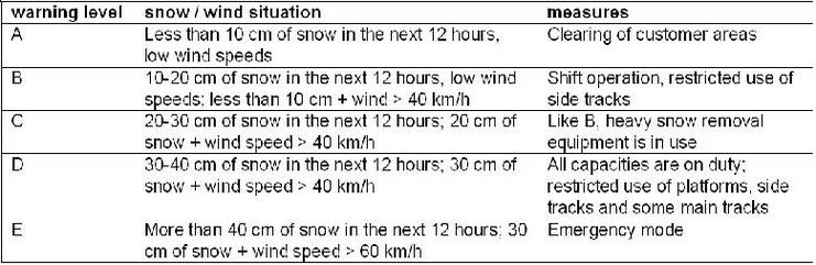
More advanced dedicated weather information systems feature clearly defined warnings with regard to extreme weather situations such has storms and gales, potential flooding, heat waves, snow avalanches etc. The respective warning levels are associated with concrete threshold values and are based on experiences. They can differ according to the region concerned and the capacity of the local personnel to deal with the corresponding situation. A certain amount of snowfall in the mountains can be totally harmless, whereas the same amount in the lower lands might already constitute a hazard.
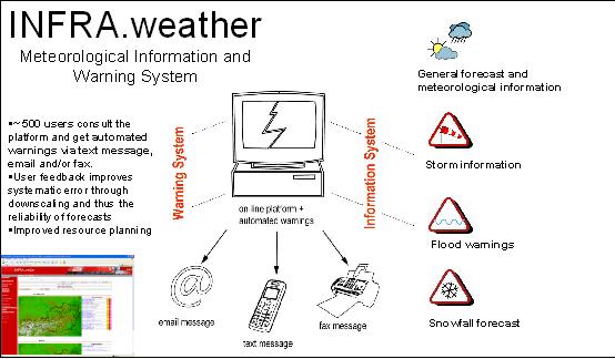
A colour coding of the different warning levels and a visualization of this information in a GIS based system is especially helpful and makes the data much easier to handle by the relevant people within the organisation. An exceptionally good example for this approach is the system Infra.Weather implemented by ÖBB. An example for the visualisation of natural hazards within the framework of this system is shown in the following figure:
The main features of dedicated weather information and weather warning systems for railways can be summarized as follows:
Temporally and spatially highly resolved weather information
related to the line section topology of railway networks
Generation of reliable weather warnings with coded warning levels
Automated distribution of weather information by e-mail and sms to all relevant users inside the organisation
Provision of additional tailored weather information relevant for the operation of railway infrastructures and rolling stock, such as water level in rivers, amount of local snowfall, information on leaf fall (slipperiness)...
Weather information is easy accessible via a dedicated online portal
Visualisation of weather data, predictions and warnings using a GIS-based overlay of railway tracks and meteorological data
The aspect of adaptation to climate change can be integrated into dedicated weather information and weather warning systems by an assessment of the current warning levels and their projection into the future taking into account the expected climate loads. These can be derived e.g. from high resolution regional climate models. The most interesting output for this purpose is the change of return periods and intensity of extreme weather events. When warning levels have to be adapted it has to be evaluated if the response processes linked with the warning levels are still appropriate under the changed conditions.
Example: InfraWeather from ÖBB
A dedicated weather information and weather warning system has been developed and implemented at ÖBB. Preparative work included the installation of additional weather stations for better spatial coverage, the development of regional meteorological model, GIS-based overlay of railway tracks and meteorological data as well as GIS-based delineation of flood risk.
The InfraWeather online portal gives access to general weather information, forecasts as well as weather warnings. A map shown on the user interface gives an overview over the Austrian railroad system with the most important weather information; beside the diagrams the information is also given in textual form with a 3h interval of forecasts.
Storm forecast
With the new forecast models and radar techniques weather extremes can be forecasted on a scale of 10 km, partly even lower. This is possible due to the definition of natural areas, units with similar natural conditions. These are meteorological divides, crests, valleys etc.
Flood forecast and warnings
The forecast of floods integrates the water level of the rivers and the meteorological data so that the warnings can be sent 12 hours in advance.
Snowfall forecast
The snowfall forecast includes the amount of snowfall in the next 24 to 72 hours for each warning point.
Weather warning system
InfraWeather has a dedicated operational warning service, which provides also real-time severe weather warnings. Extreme weather events covered by the warning system are thunderstorms, flood events and heavy snowfall. The forecast of disastrous thunderstorms is provided by using nowcasting techniques, where the track of thunderstorms can be forecasted 20 - 60 minutes in advance.
When predefined warning levels are reached, alert message are automatically generated by the system and sent via sms, email, fax and telephone to all responsible people inside the company.
Warning levels
In the following table, an example for the definition of warning levels is given: